


Khanh Son District
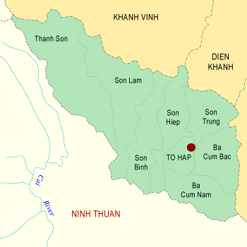
| Area: 337 sq km This is a high mountainous district, separated by the plains of the province by the forbidding pass of Khanh Son, bordering Khanh Vinh District to the North, Dien Khanh and Cam Ranh Districts to the East, and Ninh Thuan District to the South and West. The total natural area of the district is 337km2, with a population of 19,535, and a low density of only 54 persons/km2. The inhabitants live mainly on agriculture and forestry. To Hap Town is the center of the district, lying right at the axis of provincial road No. 9, 40km west of Ba Ngoi Town. The forests of Khanh Son District make up 94% of the natural area. The minority ethnic groups have now enjoyed a settlement and acquired the habit of planting wet-rice, exploiting pine resin, plating tea and coffee trees in an intensively way towards a major professional plantation area. The rich traditional culture is reflected by the set of Khanh Son Stone Musical Instruments and the culture of "gongs" typical of the highlands of Central Vietnam. In the two wars of resistance, Khanh Son was once a revolutionary base famous for heroic names such as "Death Valley", To Hap base, Ta Nia Airport. Khanh Son is rich in many valuable kinds of forest products: To Hap tree-sap as a precious kind of spice, resin of the three-leafed pine (which abounds in Khanh Son), Khanh Son tea with its renowned flavor, and coffee, which has recently become the main plant in re-structuring the economy.
| |
| Hits: 4591 | |