


Potentials of sea-island tourism
|
Rugged high mountain ranges protruding far into the East Sea have created many natural wonders and wind-free bays and lagoons. Khanh Hoa has a tropical monsoon climate with two clear-cut sunny and rainy seasons. The rains last only two months between October and November, and the rest of the year is full of sunshine, making the nice landscape even more beautiful and attractive. With these naturally endowed features, Khanh Hoa has all the conditions to develop all kinds of diverse tourist activities: tourism combined with convalescence, hunting, diving, mountaineering, exploration, conference, boating, sailing, especially sea-island tourism. Nha Trang has long been known as a sea city with many historical relics and wonderful landscapes: Hindu temples and Buddhist pagodas like Am Temple, Ponagar Tower Temples, Long Son Pagoda, Ba Vu Temple, Bao Dai Villas, Chong Rocks, Yen Islands, the Water Palace, Tru Beach, Tien Stream, Dai Lanh Beach... According the Japanese agency of ECFA, Nha Trang is a clean city with many inshore islands easily accessible by boat adorned by coral reefs around which can be viewed while snorkeling and scuba-diving. Assessing the tourism potentials of Khanh Hoa - Nha Trang, the project of VIE89/003 by OMT, the tourism developing program of PNUD and Vietnams IRDT have collaborated in formulating a document, reaching a conclusion that Nha Trang - Đa Lạt is ranked third among the 4 major tourist zones of the whole country, with a growth rate until 2005 quite higher than that of other regions nationwide.
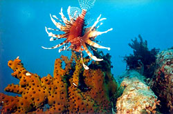
SEA AND BAYS Khanh Hoas water has the greatest depth in Vietnam and the closest proximity to the ocean and international maritime waters. . The seabed has a great and rugged declivity, layered by thousands of coral reefs. Compared to other areas in Vietnam and South-east Asia in general, Khanh Hoa enjoys far better conditions in terms of climate and topography for scientific research. Khanh Hoa s rugged coastline presents the world with the most beautiful bays and lagoons, in which Cam Ranh and Van Phong are the best known of all. Along the shore, there are many arms, lagoons, tidal beaches, and sand beaches, favorable for constructing seaports, raising aqua products, and developing sea tourism. Among these, most famous are Dai Lanh Beach, Van Phong Bay, Hon Khoi Beach, Nha Phu Lagoon, Cu Huan (Nha Trang) Bay, and Cam Ranh Bay. KHANH HOAS MAJOR BAYS AND LAGOONS
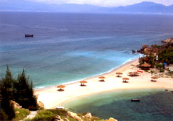
The 4 major bays of Khanh Hoa, from a north-south direction, are: Vn Phong Bay, Nha Phu Lagoon, Nha Trang Bay and Cam Ranh Bay. Each of these has its own characteristics that can serve as bases for organizing different tourist routes, clusters and sites. Typical sites are Dai Lanh Beach, Dam Mon Beach (Van Ninh), Doc Let Beach, Nha Phu Lagoon (Ninh Hoa), Vinh Luong Beach, Tien Beach, Tran Phu Beach, Tru Beach, Gravel Beach (Nha Trang), Thuy Trieu Beach, Bai Dai Beach (Cam Ranh). Van Phong Bay This is a natural wonder in a rare and ideal environment, characterized by a mild climate, a beautiful beach with fine sand, majestic hills and mountains with almost unspoilt tropical forests, multicolored coral reefs, thousands of scarce sea creatures, All these can help Van Phong develop a clear system of eco-tourism. Vietnam National Administration of Tourism has included Van Phong into the list of major tourist area for development in the long-term plan until 2010. At present, Van Phong has also been assessed one of the 4 most ideal sea tourist destinations by the World Sea Association.
Mun Island is the first natural marine reserve in Vietnam, with coral reefs and a population of primitive sea creatures, unique to not only Vietnam but to South-east Asia as well. Tam Island, Cha La Island, Ho Island, Dun Island , and Xuong Islands are those islands which do not only attract visitors with the beautiful landscapes on shore and down at the bottom, but are also a considerable income of Khanh Hoa, thanks to the presence of the nesting swiftlets. At the Second Conference of the Club of the Most beautiful Bays of the World held at Tadoussac (Qubec, Canada) in May 2003, Nha Trang Bay was recognized as an official member of the Club - a great opportunity for Nha Trang-Khanh Hoa to propagate its profile. Cam Ranh Bay Cam Ranh is ranked as one of the three best seaports worldwide with the best natural conditions, with an area of closed bay of 60 km2 and an average depth of 18 - 20m, sheltered from the wind by surrounding mountains. Cam Ranh is only 1 hour of boat from the international maritime waters (compared with Hai Phongs 18 hours). Some other ports are still operating in the bay such as the port of exploiting sand, Ba Ngoi Port, Da Bac Fishing-port and the naval port. Nha Phu Lagoon (Ninh Hoa) is surrounded by by Heo Peninsula with an area of some 100km2. In the middle of the lagoon are a number of islets, of which Thị Islet with a peak of 220m. The islet cluster of Thi Islet, Lao Islet, and the eco-tourist area of Hoa Lan (Heo Mount) forms a tourist ensemble north of Nha Trang. | |
| Hits: 4846 | |
 A
A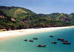 With a 385 km rugged seashore and hundreds of islands of all sizes and immense white sand beaches, Khanh Hoa has got all the priorities for developing sea tourism, especially sea-island tourism.