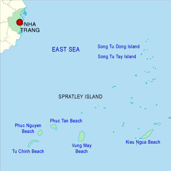


Truong Sa Island District
| Area: 496 sq km This is an island district with an area of 496 km2, lying in the southern part of the East Sea, consisting of 20 islands and about 100 submerging rock stretches of coral origin. The farthest island from the mainland is 250 nm off shore. On many of the islands, the vegetation grow naturally, especially Phong Ba which can resist the harshest storms. On the surface of the islands is a thick layer of birds droppings with a reserve of millions of tons - a valuable source of natural phosphate fertilizer. The aqua products of Truong Sas waters are quite abundant, especially the red corals - an extremely precious now being studied by the worlds medical circles in search of a pharmaceutical that may be used in cancer treatment. Truong Sas seabed is also a promising source of oil potentials. In order to develop the economy of Truong Sa island district, mainly fisheries, Khanh Hoa's authorities and the Ministry of Fisheries have had two major fishing-ports built at Da Tay and Truong Sa islands as the sheltering place for the fishing peoples vessels. The provincial authorities are focusing on granting financial support to fishermen to build new fishing ships with greater output for long-term seafaring around Truong Sa archipelago. This has opened up promising perspectives for the exploitation of great potentials of these territorial waters of Vietnam.
| |
| Hits: 6438 | |