


Cam Ranh Town
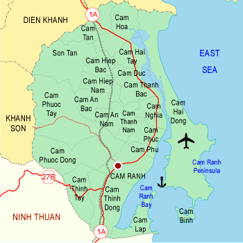
| Area: 697 sq km Cam Ranh Town is situated at the southern end of the province, adjoining Nha Trang and Dien Khanh to the North, Khanh Son District to the West, Ninh Thuan Province to the south, and Cam Ranh Peninsula to the East. Here, the famous Cam Ranh Bay (20km long, 10km at the widest place, 18,2m of average depth with 30m at the deepest, and the bay entrance 3km in width, sheltered by Binh Ba Islet from winds and waves) can be compared with San Francisco Bay of the United States and Rio de Janeiro Bay of Brazil. The total natural area of the whole district is 697km2; its population is 220.630 with an average density of 307 persons/km2. The inhabitants lie mainly on agriculture, fisheries, salt-making, forestry, commerce and seaport services. Ba Ngoi Town, the administrative capital of the district, has Da Bac Seaport (also called Ba Ngoi Port). This is a commercial port situated within Cam Ranh Bay, the door for exporting salt from Cam Ranh and Ninh Thuan Province. Ba Ngoi Town lies along National Highway 1 and at the junction with provincial road No. 9 leading to Khanh Son. The town is about 60km from Nha Trang in the north and 40 km from Phan Rang Town in the south. Cam Ranh has lots of famous landscapes such as Rong Mount (Dragon Mount), Qui Mount, Cam Linh Mountain, Cam Ranh Lake, Bai Dai (Long Beach), as well as other important relics like the temple for the Headless General, Cam Ranh Prison, Ba Thin Fields, Ao Ho... Cam Ranh has long been known for specialties such as Thuy Trieu mussels, Binh Ba lobsters, Tra Long shells, tai tuong conch, Cam Ranh salt, resin, Thanh Ca mango... Cam Ranh also abounds in minerals: ilmenite, quartz... But perhaps most famous of all is Thuy Trieu silica sand, an ideal material for the industry of making glass, crystal, and optical lenses.
| |
| Hits: 7894 | |